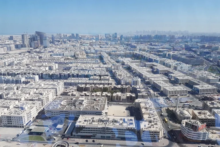
Al Raffa is a district of Dubai, 867 m from Sharaf DG Metro Station.
Al Raffa is a subcommunity of Bur Dubai located in western-central Dubai. It sits within the Bur Dubai area and is recorded in Dubai mapping with coordinates 25.25688 N, 55.28904 E. The neighbourhood is positioned close to central Dubai and commonly appears in property transaction records and local area summaries used by buyers, renters and agents.
Al Raffa is a named subcommunity within the district of Bur Dubai. It is part of the built-up central corridor of the city that lies west of Dubai Creek and north of some of the oldest urban districts. Official mapping and property datasets identify Al Raffa by its name and geographic coordinates; administratively and for everyday orientation it is treated as a sector of Bur Dubai. The site path used in local guides is “Dubai > Bur Dubai > Al Raffa”.
Geographic coordinates: 25.25688° N, 55.28904° E. The area is served by Dubai’s public transport network and sits within easy reach of major city destinations, which makes it part of the inner-city commuting zone.

Public transport: Al Raffa is located within walking distance of a Green Line metro station. The recorded distance to the Green Line station coded G25 is 867 metres and the station is marked as walkable in local transport summaries. This provides a direct metro connection to other Green Line stops and interchange points across the network.
Road and driving times: Multiple reference summaries list typical drive times from Al Raffa to several key destinations in Dubai. Indicative drives include approximately 13 minutes to Dubai Mall, about 25 minutes to Palm Jumeirah, around 23 minutes to Burj Al Arab and roughly 29 minutes to The Walk JBR. Drive times vary with traffic conditions and time of day.
Measured straight-line and road distances to key Dubai locations (as recorded):
These distances give a clear picture of Al Raffa’s position relative to central business districts, major shopping destinations and leisure areas: it is inside the broader central ring of Dubai with reasonable access to the financial and tourism hubs by car and public transport.
The area is included in local property transaction datasets; there are 50 sale transaction records available for Al Raffa in the latest published dataset referenced by local property portals. The neighbourhood is documented as part of established urban Bur Dubai rather than as a single large development site, and current public data lists a small set of nearby projects rather than large on-site masterplans.
Projects recorded in the vicinity (as listed in local project summaries):
Project records in the provided dataset do not include developer names, registration numbers or completion dates for these entries. No projects on-site with public links were included in the source data for this location. The projects above are referenced by name in local listings and project catalogues used by property portals and agents.
Local summaries note that Al Raffa has several schools in its immediate vicinity. Two schools mentioned in council and property portal summaries are New Academy School (approximately 0.5 km away as referenced) and Ambassador School (approximately 0.8 km away as referenced). These proximate educational institutions are commonly cited when assessing family-oriented convenience from properties in the neighbourhood.
Other service-level detail (clinics, hospitals, shopping centres operating in-block) is not listed in the provided location dataset; however the recorded distances and metro access position Al Raffa within short travel reach of the larger medical, retail and entertainment facilities in central and western Dubai.
Al Raffa is appropriate for people who prioritise proximity to central Dubai and easy access to the Green Line metro. Its location inside the Bur Dubai corridor means it is a practical choice for residents who commute to Downtown Dubai, DIFC or Business Bay and who value direct connections to Dubai International Airport.
The documented accessibility—walkable access to a Green Line station (G25) and short drives to major destinations—also makes the area suitable for households that require regular access to citywide amenities while remaining within an established residential district. The presence of nearby schools cited in public summaries adds to the suitability for families who need school options within short travel distances.
Q: Where exactly is Al Raffa?
A: Al Raffa is a subcommunity of Bur Dubai, identified by coordinates 25.25688 N, 55.28904 E. It sits within the western-central urban area of Dubai and is included as a named sector within Bur Dubai mapping and property classifications.
Q: What public transport serves Al Raffa?
A: The neighbourhood is served by the Dubai Metro Green Line. A Green Line station with code G25 is recorded at 867 metres from the centre of Al Raffa and is described in local summaries as walkable. This provides direct metro access across the Green Line and connections to other metro lines at interchange stations.
Q: How long does it take to reach major Dubai destinations?
A: Reference drive times published in local summaries indicate roughly 13 minutes to Dubai Mall, about 25 minutes to Palm Jumeirah, around 23 minutes to Burj Al Arab and roughly 29 minutes to The Walk JBR. Measured distances to key points are also recorded, for example 6.8 km to Burj Khalifa / Downtown Dubai and 7.7 km to Dubai International Airport (DXB).
Q: Are there development projects or recent transactions in the area?
A: The public dataset referenced records 50 sale transactions for Al Raffa. Nearby project names listed in local project summaries include Al Raffa Residence, Manazil Al Raffa 01 and Masaken Al Raffa 01. Project-level developer names and completion details were not supplied in the provided dataset.
Dubai market as a whole: prices, transactions and trends (DLD data) →



Nothing found. Try relaxing the filters.
Neighbouring areas and sub-communities to compare location and prices.